Posts

Showing posts from 2021

Tizi Ouzou

Image
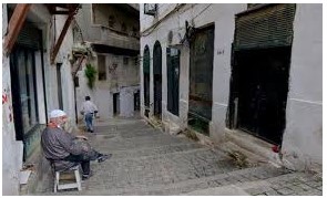
  Tizi Ouzou Tizi Ouzou or Thizi Wezzu (Berber: Tizi Wezzu or Thizi Wezzu, ⵜⵉⵣⵉ ⵡⴻⵣⵓ ) is a city in north central Algeria. It is among the largest cities in Algeria and is the capital and largest city of Tizi Ouzou Province. It is the second most populous city in the Kabylie region behind Béjaïa. Etymology The name comes from the Kabyle phrase Tizi Wezzu and is pronounced quickly Thiziwzzu, commonly Tizi or Thizi which means the "mountain pass", while Azzu means the "Forsythia" (the preposition n / en, which means: "of / related to", is not pronounced here), hence the city is often referred to as "The gap of Forsythia" Friction Islamists looted, and burned to the ground, a Pentecostal church on 9 January 2010. The pastor was quoted as saying that worshipers fled when local police left a gang of local rioters unchecked. Geography This city is located in the heart of Kabylie. It is 102.36 square kilometres (39.52 sq mi) in area. Tizi

Casbah of Algiers

Image
  Casbah of Algiers The Casbah (Arabic: قصبة ‎ , qaṣba, meaning citadel (fortress) is specifically the citadel of Algiers in Algeria and the traditional quarter clustered around it. In 1992, the United Nations Educational, Scientific and Cultural Organization (UNESCO) proclaimed Kasbah of Algiers a World Cultural Heritage site, as "There are the remains of the citadel, old mosques and Ottoman-style palaces as well as the remains of a traditional urban structure associated with a deep-rooted sense of community History The Casbah of Algiers is founded on the ruins of old Icosium in the 10th century. It was a city built on a hill, goes down towards the sea, divided in two: the High city and the Low city. One finds there masonries and mosques of the 17th century; Ketchaoua Mosque (built in 1794 by the Dey Baba Hassan) flanked of two minarets, Djama’a al-Djedid (1660, at the time of the ottomans) with its large finished ovoid cupola points some and its four coupolettes, Djamaâ el

Al Hoggar

Image
  Al Hoggar Or Al-Ahaggar is a famous mountain chain located in the far southeast of Algeria in the state of Tamanrasset. The ancient rock murals indicate this, and this region has become a barn for its importance in Algeria and the world. It is an area known internationally for its stunning scenery and attractive charm. In the Hoggar Mountains, there is one of the highest peaks in Algeria, namely: the summit of Tahat Atakur 3003 m. There is also one of the most beautiful passages in the world, the Skram Pass, from which you can see the most beautiful sunrise and sunset in Algeria. And recognized by UNESCO.

Algeria

Image
  Algeria Introduction Algeria  is the capital and largest city of Algeria. The city's population at the 2008 Census was 2,988,145[3] and in 2011 was estimated to be around 3,500,000. An estimate puts the population of the larger metropolitan city to be around 5,000,000. Algiers is located on the Mediterranean Sea and in the north-central portion of Algeria Algeria  is situated on the west side of a bay of the Mediterranean Sea. The modern part of the city is built on the level ground by the seashore; the old part, the ancient city of the deys, climbs the steep hill behind the modern town and is crowned by the casbah or citadel, 122 metres (400 ft) above the sea. The casbah and the two quays form a triangle Monuments Tamina (eaters) Tamina (or zrir) is a traditional Algerian dessert, made with semolina, honey and butter. It is served on occasions and holidays. How to prepare Toast the semolina well in a frying p

Relizane

Image
  Relizane (Btifinagh: Relizane in Tifinagh.svg in Berber: Gil ni Izan, French: Relizane) is one of the municipalities of Algeria and the headquarters of Relizane wilaya and Relizane district. Location It is located to the west of Algeria, bordered to the east by Chlef and Tissemsilt, to the south by Tiaret and Maskar, and to the west by Mostaganem. Date Relizane is closely related to the history of Algeria, as it has the oldest metropolitan areas and scientific centers, such as the Bani Rashid Castle, which is a scientific, spiritual, industrial and military bus station since the Ottoman era, and the city of Dahra, we find Mazoona, the capital of the West after the occupation of Oran by the Spanish. Among its most important figures and guardians are Sidi Ahmed bin Yusef al-Qalai, al-Sabbagh al-Qal’i, Sidi al-Sharif al-Mazouni, Sidi Yahya al-Maghili, the Mazuni, the owner of the hidden pearls, and Sidi Boutaleb al-Muammar al-Mujahid. Ibrahim Al-Tazi, a student of Sidi Al-Hawa

Batna

Image
  Batna Batna is the main city of Batna Province, Algeria. With a population of 290,645 (2008 census)[1] it is the fifth largest city in Algeria. It is also one of the principal cities of the Chaoui area and is considered the capital of the Aures. Snow in Batna Located in the Aurès Mountains (part of the Atlas Mountains), at 1,048 metres (3,438 ft) above sea level, Batna has a cold semi-arid climate (Köppen climate classification BSk) with Mediterranean influences and an average annual precipitation of 326 millimetres (12.8 in). Summers are moderately hot (by Saharan standards) and dry and winters are chilly and wetter, with the possibility of snowfall. Dining and nightlife With regard to night life, due to some religious and cultural limitations, there are almost no night clubs in the city. However, the existing nightlife is concentrated in the heart of the city, around Les allées Benboulaïd and "STAND" areas, especially during summer break. Downtown Batna has plen

Peace

Image
  Peace Peace is an occurrence of harmony characterized by lack of violence, conflict behaviors and the freedom from fear of violence. Commonly understood as the absence of hostility and retribution, peace also suggests sincere attempts at reconciliation, the existence of healthy or newly healed interpersonal or international relationships, prosperity in matters of social or economic welfare, the establishment of equality, and a working political order that serves the true interests of all. Organizations United Nations The United Nations (UN) is an international organization whose stated aims are to facilitate cooperation in international law, international security, economic development, social progress, human rights, and achieving world peace. The UN was founded in 1945 after World War II to replace the League of Nations, to stop wars between countries, and to provide a platform for dialogue. The UN, after approval by the Security Council, sends peacekeepers to regions wher

Constantine

Image
  Constantine Constantine also spelled Qacentina or Kasantina, is the capital of Constantine Province in   northeastern Algeria. During Roman times it was called Cirta and was renamed "Constantina" in honor of emperor Constantine the Great. It was the capital of the French department of Constantine until 1962. Located somewhat inland, Constantine is about 80 kilometres (50 miles) from the Mediterranean coast, on the banks of the Rhumel River. Constantine is regarded as the capital of eastern Algeria and the commercial center of its region, and it has a population of about 450,000 (938,475[4] with the agglomeration), making it the third largest city in the country after Algiers and Oran. There are several museums and historical sites located around the city. Constantine is often referred to as the "City of Bridges" due to the numerous picturesque bridges connecting the various hills, valleys, and ravines that the city is built on and around. Constantine was nam

Human body parts

Image
  Human body parts